Tuesday, June 12, 2012

Kicks: Day Eighteen (The End of the Road)

IMG_4487smLast night, we stayed just a little south of Victorville, in Hesperia. It was right by where we needed to pick up our Route 66 trip this morning, and it...you know...wasn’t in Victorville! So that worked out well!

The first thing we encountered was Cajon Summit and Cajon Pass. Not only was this a beautiful descent through the mountains, there were stretches of the other two lanes of 4-lane Route 66 that were open for, if not driving, pulling over and checking out. You could see where they had added on to make the lanes wider, and it was neat to see the old Road still intact, even though it was closed off. (The guidebook mentions that this is now often the site of “illicit activity.” I’m not quite sure what sort of illicitness was happening there, but we did notice a few cars parked along the way, usually with one guy driving. Sex? Drugs? I do not know. We were just there to check out the Road! Ha!) It was really a neat drive, one of the prettiest we’ve encountered along 66.


One of the neatest things was the suggestion of the guidebook to look back at the silos (some sort of plant) as we passed Devore. The concrete slab that extends off from the curve of current Route 66 is the original 66, paved “well before 1926.” And we saw it! The book said, “This is possibly the only example of this type of Route 66 pavement left!” I don’t know if that means in California, or on all of Route 66; we have seen quite a few other examples of original Portland concrete, but this was possibly a unique concrete used here. It did seem to be more full of rocks, rather than smooth concrete.
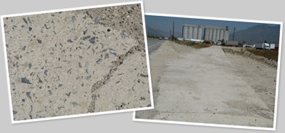
Yes, I’m fascinated by the composition of the Road’s pavement, too. But how rare is it to have original pavement left from almost 100 years ago?? Most of this stuff has long been paved over. It’s a treat to encounter that original concrete, and especially the brick pavement!

We soon came to a long stretch of towns large (San Bernardino) and mostly small (San Dimas, Azusa, Monrovia, and several others) that marked the path of 66. There were a few crummy areas, but many of these small towns have embraced their Route 66 heritage, and it is really played up along some stretches. Not a lot of original signage remains, but old buildings (many still in use) abound.

We were happy to encounter the seventh and final Wigwam Motel built in the country, and the second on Route 66, in Rialto. We stayed in #6, in Holbrook, Arizona, and the one here has also been restored and preserved. It’s a beauty, with more teepees than the one in Holbrook, and set in the midst of a green oasis with palm trees. Lovely!
IMG_4502sm
Much of Foothill Boulevard (originally Route 66, and marked as Historic Route 66) is strip malls and newer places, but there are still a lot of fun things to see along the way. I really liked Bono’s Historic Orange, one of the classic orange stands, and possibly one of the last Giant Orange Stands that once populated the roads here. I don’t have a date for this, but the nearby Bono’s Restaurant dates to 1935.

I’ve always loved the name of the town, so we stopped in Rancho Cucamonga for some lunch and a beverage. The lunch was good, the service not so good, but we didn’t let it spoil our day. What’s the point of that?

One of the things I was excited to see was the Foothill Drive-In Theatre sign. The drive-in has been closed for a while, but it seems that the beautiful sign will be preserved. It looks to be in excellent shape, so long live the drive-in! Or at least their signs!
IMG_4517sm
A cool spot in Arcadia was a building that apparently is typical of California drive-in style. It is currently a Denny’s, but this building once housed the last of the Van de Kamp’s restaurant chain on Route 66. What a great roof, and that is one big windmill!

After cruising through the little towns along Foothill, we entered Pasadena, made our way north of LA, and through Hollywood and Beverly Hills. (Did you know that old 66 went through Beverly Hills?) As we approached Santa Monica, I began to get really sad, because I knew that our Route 66 journey was almost at an end. A couple of blocks away from the official end at Lincoln and Olympia, I cried like a little girl. The official end is anti-climactic, with just a street corner in Santa Monica. No big signs announcing the end or anything like that. It’s kind of odd that after all the signs and tributes along the way from Victorville, the official end is essentially ignored by everyone except those who know the significance of this intersection. I didn’t notice it right away, but Ken pointed it out to me, saying “How appropriate!” On the opposite corner was a business (I think it was a dry cleaners) with a big penguin on its sign! The penguin was even looking towards the intersection that is the end of Route 66. That made me happy!
IMG_4521sm

The UNofficial end to Route 66 is considered to be the Will Rogers monument in Palisades Park, at the end of Santa Monica Boulevard. Although I got choked up there, too, I think I’d spent my emotions at Lincoln and Olympia, so I managed to keep myself under control.

I’ll write more about my thoughts on Route 66 after we get back, and I’ll have more pictures of Santa Monica Pier tomorrow (including the famous gateway to the Pier), but for now, I’m physically and mentally exhausted. Ken and I have had a quiet evening, just trying to regroup and settle in at our digs in Marina Del Rey. We’ll be meeting our friend Marty for dinner tomorrow evening, spending some time with Ken’s cousin Ros and her family, then attending our friend Andy’s graduation from Cal Tech, and THEN (I’m exhausted already!) meeting with our nieces from San Diego, and good friends Kim and Steve.

A fitting end to today’s entry is this:

Monday, June 11, 2012

Kicks: Day Seventeen (Iconic sign, movie set, and bottles galore)

IMG_4419smAfter a quick stop to see the El Garces renovation in Needles (a former Harvey House, this 1908 building is in the process of restoration), we headed out into the Mojave Desert.

This was a rather amazing leg of our journey, at least for a midwestern girl. The remoteness of the place is sobering and a reminder of the vastness of our country. Although it was not much to look at, I was fascinated by the refurbished rest area, one of the first on Route 66, dating to the 1950s. There wasn’t much there back then...just a few picnic tables. Today all that is left is some concrete pillars that anchored them. The sign at the rest stop states: “Stop a moment. Listen to the quiet. Experience the spirit of Route 66 that lives on in the travelers of today.” As one of those travelers, I appreciate that sentiment, and I can testify to the quiet of the desert. We heard nothing but the sound of the wind.


IMG_4403 
From Essex to Amboy is a constant string of names spelled in rock on the northern embankment. The author of my guidebook calls it “public art,” and although it isn’t anything more than words made out of rock, it’s oddly charming. To me, it shows the fascination of Route 66...there are miles of these rock words in the Mojave desert, made by travelers from all over the world.

IMG_4412sm
Cadiz Summit (which is no longer a town) is also another form of artistic expression, and people have spray-painted the few structures remaining. Also oddly charming, but also more than a little creepy. If the end of civilization as we know it eventually happens, this is what things will look like.

IMG_4421sm
Just before Amboy is the Roadrunner’s Retreat Cafe and Station, and the sign is great. Sadly, it wasn’t until I edited the picture of the sign that I saw that the roadrunner’s head is missing! Oh no! This would be a great sign to restore, but I’ve heard nothing about any plans to do that. This was also a rather unpleasant encounter with humanity. As we drove up, we saw some guy set up with his tripod and camera gear. He shook his head at us, like “Stay away. I’m busy here.” We both had the attitude of “Oh, really?” I said to Ken, “So who died and made HIM the lord of the Roadrunner?” We pulled up, and I got out and took my pictures. If he was doing some sort of official shoot (and I really don’t think he was...I think he was just being a dick), get a permit from whatever town or authority regulates such things, get it roped or barricaded off, and do your thing. Otherwise, don’t you shake your head at me and expect me to drive on by and not get a picture. Damn straight.

On a happier note, our next stop was in Amboy, at pretty much the only place to stop in Amboy: Roy’s Motel and CafĂ©. This is probably the most famous sign on all of Route 66, as it has made appearances in several films. It is an especially large sign, the cabin motel is classic, and the motel office with its swooping roof over the wedge building is a great design that looks fantastic in pictures and on film. They are working on restoration of the entire complex; the gas station and cafe have already been renovated and are open for business. The cabins seem to be in the process of restoration, and although the guy manning the counter in the cafe didn’t seem to know much about it, he did say that the plan is to renovate them all and open them to tourists. I hope the work continues!
IMG_4431sm
I was able to take a few pictures of the interior of the office through the windows. This turned out to be a pretty neat shot…do you see what makes it kind of cool?

Near Amboy is the Amboy Crater, a lava flow that Route 66 cuts through. I don’t think I’ve ever seen a lava flow before, and I was pretty impressed. We encountered several more along the way, an indication that this area was once pretty active when it comes to volcanoes. It was neat to see, and Ken actually climbed one of the bigger hills of lava by the road.


The Road out of Amboy is pretty rough in spots, probably the roughest we’ve encountered other than dead end spurs. It’s still very travel-able, though, and a great trip through the desert! Next up was the new location of the Bagdad Cafe. It was formerly located several miles to the east (we passed the former location, now marked only by a tree and a small, empty lot), and the owner moved it to its new location. Amazingly enough, I’ve never seen the movie, only know about it from my Route 66 readings. (I’ll remedy that soon enough.) Apparently, this is a major cult movie in France, and the majority of their visitors are from there, and many more from Europe. There are football flags hung all over this little hole in the wall place, and the guestbook is full of signatures, notes, and drawings from people all over Europe.

We ended up talking to Bill, an interesting character who turned out to originally be from our neck of the woods. I told Ken that I’d guess that about 50% of what he told us was true! It was an interesting place, and the curvy booths were super cool.


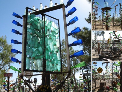
Several miles farther on through the desert, we came to the Bottle Tree Ranch, which was a favorite of both of ours. Elmer Long created this oddly beautiful art installation, with metal posts bearing glass fruits of many colors. Many of the “trees” are topped with old objects, and are interspersed with things like old typewriters and old stoves. The sunlight was hitting the bottle trees just right, and it made me think of a forest of jewels. There was a “tree” that consisted of an old sign filled with green plastic bottles, and even THAT had a beauty of its own. It was a nice reminder that beauty is where we find it, and sometimes where we make it.

Saturday, June 9, 2012

Kicks: Day Sixteen (Twists, turns, and donkeys)


Before I get to any of that, first are some pictures for Cousin Shane. He wrote to me to be sure to check out the Santa Fe Railroad engine, car, and caboose on display in Kingman and to think of his Dad, because his Dad loved that train and always wanted to stop and see it. I had already done so—I remember how much his Dad loved trains, so I’ve thought about him a lot on this trip—but  this morning, before we left Kingman, we made sure to stop and get pictures. For Shane and John.

Then we were on our way out of Kingman, with our main activity today the drive and visit to Oatman. After a straight shot out of Kingman through some drier and more desert-like terrain, we began the climb into the Black Mountains. I’ve heard from numerous people that this stretch of Road is pretty wild, and they weren’t kidding! My guidebook says that no trucks over 40 feet are allowed on this stretch (and it’s posted), and recommends that large RVs not attempt it. I second that emotion, STRONGLY. I can’t imagine trying to take a large vehicle up this stretch of Road.


I’ve been on some twisty roads in my life, most notably through part of the Great Smoky Mountains and back roads in Georgia, as well as the Pacific Coast Highway. I’ve never seen anything like this stretch of Route 66! Frequent hairpin turns, with steep inclines both going up and coming down. Loops that double back, but with a really tight turning radius...no gradual, graceful turns here, just unbelievably tight turns with a speed limit of 10 mph posted on those sections. No or minimal guard rails (thank goodness for that 6-inch high rock wall...I’m sure that would keep a car from going over!), and precipitous drops to the canyon floor. It was awesome! I told Ken that I’m glad I’m not afraid of roads like that, because they make for some really amazing drives. This was one of the funnest and coolest—I might even say THE coolest—stretches that we’ve encountered.

 
I hadn’t seen a whole lot in the way of cactus so far, other than prickly pear (and we even have that in Indiana), but today I saw two little barrel cacti up on a hillside. They looked kind of lonely, but they were blooming, so I guess they were doing okay! There were some interesting rock formations along the way, including one that we both thought looked like a face. Signs caution to watch for both burros and big horn sheep, which are occasionally seen on the road. We didn’t run across (or run into) any, but we saw frequent deposits that indicated they had been in the area!

On the way up, we went through a place called Goldroad, where there were gold mines. It looks like they were still mining for something there, and although a few people suggested a tour of the mine, I didn’t see where they were still offering tours to visitors. They may have stopped that. Sadly, there were no good places to pull off on this particularly twisty section, because there were remains of the original mining town from the 1800s. I saw several remnants of stone walls...can you imagine what life must have been like for a miner living in that tiny town in the 1800s?

One of the things we found going up (mentioned in my guidebook, but Ken spotted them before I did) was steps cut into the rock. These went up to what is called Shaffer’s Fish Bowl Springs, a basin someone made to collect the water that seeps from the rock there. It was pretty dry when we got up there, except for a couple of spots of moisture on the rock wall, but looking back at the way we had come offered some amazing views. It was an easy climb, and the view was well worth it!
We finally got closer to Oatman, and there were several trailers and small structures (I think they still do mining there, too) on the outskirts of this small town. It was more than a little surprising to cruise into the town itself and see all kind of cars and motorcycles parked, lots of people milling around in an almost carnival atmosphere, and numerous gift shops and snack shacks! Here was this tiny little mining town in the Black Mountains, not easily accessible, and it was just teeming with tourists.

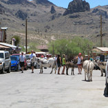
If you’ve never heard anything about Oatman, Arizona, it is famous for mainly one thing: the burros. They are not native to the area, and were brought in to work as pack animals for the mines. When most of the mining stopped and they were no longer needed, they were set loose into the mountains. They managed to survive, but they kind of returned to the town and took it over as their own! They wander around the streets freely, and are protected animals. Every little tourist shop sells food for them, and you can hand-feed them. We saw people feeding them carrots, and that’s what I had always heard you gave them, but when we asked at a place, they said that carrots aren’t good for them (they can’t digest them well, and it makes them aggressive), and alfalfa is what is best for them. She said there was a baby (with a tag on his ear...we had seen him), and you can’t feed him anything at all. It’s sad that there are still people selling carrots in the town. I’m not sure why they don’t enforce that better. It wasn’t just this vendor telling us this. We also heard it from the bartender at the place where we stopped to eat.
Speaking of that, after walking Oatman’s one street, it was lunchtime, so we stopped at the Oatman Hotel and Cafe. It was built in 1902, and it is the place where Clark Gable and Carole Lombard spent their honeymoon. Apparently they liked the anonymity of the place, and would often come for a visit. Clark would play cards with the miners. (Cool!) They’re still doing great business, and we enjoyed our cool amber beverages and our pulled pork barbecue sandwiches. They serve “burro ears” with the sandwiches: potato slices cut lengthwise and fried like chips. Tasty! When things quieted down a bit, we chatted a little more with the bartender, Michelle, and she was a real sweetheart. We asked about whether a couple of the burros were pregnant or just fat. (I had noted that a couple of them HAD to be pregnant, but because they get so much food fed to them, they might just be really fat.) Michelle cracked us both up when she said, “They’re ALL pregnant!” She asked if we’d seen the baby, who was about three weeks old. We said yes, and she said that his mother is the only one who isn’t pregnant. Haha!

She told us that it’s a herd of maybe 15, and there is only one male, but he really gets busy. He’s got a broken ear and is all scarred up, because he has to defend his territory. It was really fun to talk with her and she gave us a lot of good information about the donkeys. She offered to take our picture, and wished us a safe trip. Oh, and for whatever reason, people who come there often write their names on a dollar bill and staple it to the wall. And the ceiling. And the window frame. They’re everywhere, and you can probably see that some of them are very yellowed and old. Michelle said that the oldest one they found is from 1923, and that particular bill is protected in plastic right behind the bar on the wall.

Today was the shortest travel distance of any of our Route 66 days, but it was probably one of the funnest and most interesting. The spectacular views of the starkly beautiful Arizona terrain were just breathtaking, especially for someone like me who has spent very little time in the Southwest. Tomorrow will be one of our longest travel days, about 175 miles to Victorville. Probably no burros, though!

Kicks: Day Fifteen (Dead ends and an ice cream cone)

IMG_4268smA little west of Flagstaff is Bellemont, and although the town doesn’t have much to offer to the Route 66 traveler (I don’t mean that in a mean way...there just isn’t much Road or road artifacts left to explore), it did have a short spur of old 66 that was pretty cool in a couple of ways.

The spur heading west from the exit for Bellemont was said to have the Pine Breeze Inn, which was one of the locations for the movie “Easy Rider.” We cruised down the dead end road, which got a little bumpy after a while, and despite the one abandoned gas station, we didn’t see anything that was looking like Pine Breeze Inn. We came to the dead end, and I even got out and walked a little ways past the barrier to see if I could see anything further down the road. I wondered if it hadn’t been torn down, but Ken said, “Unless it was that old gas station we passed.” Sure enough, when we came back to it, I spotted the faded letters on the side of the building saying that this was Pine Breeze Inn. I was even able to get a couple of decent pictures of the interior, and the little cabins behind the station. The property is for sale, with the sign proclaiming that the realtor is Sotheby’s International Realty. I don’t know if that is part of the actual Sotheby’s, but it sure sounded important. I’m definitely going to have to watch the movie again (it’s been years since I saw it) so that I can spot the Pine Breeze!

On the spur that headed east, there were no ruins...other than the Road. It got pretty rough in spots, and Ken took it easy. It was sad to me to see the pavement starting to completely break away. It was a deep red pavement that I’ve seen in a couple of other spots, and I think that was paved over the original concrete. There were large holes in several spots, and it’s amazing to me how a road can deteriorate so quickly if it’s not maintained. Of course, Ken pointed out that this old spur was closing in on 100 years old, and that’s true. I tend to think of it as “a few decades,” but we’re already at about eight of those, which is definitely more than a few! That was a neat drive.

Another neat drive was the pre-1941 route out of Bellemont (on the other side of I-40) to Parks. This took us through part of Kaibab National Forest, and it was a truly beautiful drive through stands of large pines and green grass. We passed over Fortynine Hill (the highest point of Route 66) and encountered a short hiking trail that was a 1931 alignment of Route 66. It is a dirt trail now (we found horseshoe prints, so at least someone uses it as a horse trail), except for a small concrete bridge that survives. Although we could hear the traffic on I-40 in the distance, this was a lovely place with lots of pines and shade, and the pine smell was wonderful.

We soon encountered another dirt portion of old 66, called Deer Park Road. This dirt road was in good shape and easily drivable, and as we came up over a rise, with the mountains in the distance, we saw a small herd of cattle coming our way down the road. A few cowboys were moving them along, and it was such an unexpected and fun moment that we’re both still grinning about it. The cowboys got them around our car and off the road onto the sides, and I waved at the cowboys (they waved back). It’s one of those things that you rarely never see in Indiana, and it was a neat moment!

Then it was onwards to Williams, and we both really liked this little town. They have really embraced their Route 66 bona fides, and they had a really cute downtown area. There was some sort of biker rally going on, so there were lots of people and motorcycles, the restaurants and pubs were doing great business, and music was playing downtown. It was probably the happenin’-est little town we’ve encountered on Route 66, and we both loved it. Great job, Williams! After we cruised around checking it out and I got pictures of motel signs, we stopped for a light lunch at Rod’s Steakhouse. It wasn’t quite as busy as some of the other places, and it was a neat little place right on Route 66.

Ash Fork was a pretty sad little town after the vibrancy of Williams. I told Ken it was a good lesson as to town management, because it’s obvious that Williams did something right and Ash Fork took a wrong turn. Williams had a downtown filled with cars and bikers and people visiting their restaurants and staying at motels; Ash Fork was dreary and deserted. I honestly don’t understand any town on Route 66 that doesn’t invest in developing that aspect of tourism. People come from all over the world to do this trip, and if you build it, they will come!

After Ash Fork, we were able to get off of the Interstate for most of the rest of the day’s journey. There is a large stretch of 66 in Arizona that although not original concrete, is very nice road following the path of Route 66. The next stop was Seligman, which is another little town that has embraced Route 66. The Delgadillo brothers were and are great ambassadors for Route 66. Juan passed away in 2004, but his Snow Cap Drive-In lives on. It’s a fun and funky little place, and one of the stops that you can’t miss. It was doing great business, and we enjoyed our ice cream cones as we sat out in the chairs facing Route 66 to catch the breeze and the shade. We also got a kick out of this motel, especially the “pets welcome” part. I told Ken, “Yes, pets welcome...as long as you keep them on the roof of your motel room!”
Peach Springs was a quick trip through town, as was Truxton, Crozier, and Valentine. Hackberry was a different story, because that is where Hackberry General Store sits. Famed artist and Route 66 icon Bob Waldmire created the station, and it is a wonderful collection of old gas pumps, various car paraphernalia, Route 66 signs and memorabilia, and even a gorgeous ‘56 Corvette. Mr. Waldmire passed away not too long ago, but there are plenty of people who still enjoy his art and his efforts, so he has left a wonderful legacy. Along the way out of Hackberry, along the Antares Curve, we encountered this fellow, and I had to get a couple of pictures for Shane! As the guidebook said, it’s “delightfully” out of place in the desert, and wonders why such a thing would be out there. The answer...Why not? We soon arrived at our destination for the evening, Kingman. I got my requisite googie sign fix, and then we got a nice room at SpringHill Suites. Our room is modern but with a retro twist, and this is the second couch I’ve loved in one of our hotel rooms! (I know it’s lame that I take pictures of motel room furniture, but this really is a cool couch!

IMG_4335sm 

Tomorrow we have a short day distance-wise, but it’s a very twisty drive up into Oatman. I’m hearing from lots of people that this is one of the best parts of doing Route 66. Details tomorrow, but for now, one word: DONKEYS!